Quick Facts
| Max altitude | 5,364 m (Everest Base Camp); 5,545 m (Kala Patthar viewpoint) |
| Total distance | ~130 km round trip (Lukla–EBC–Lukla) |
| Duration | 12–14 days including 2 acclimatization days |
| Difficulty | Difficult — high altitude, no technical climbing |
| Best months | March–May, September–November |
| Permits | Sagarmatha National Park entry (NPR 3,000) + Khumbu Pasang Lhamu Rural Municipality permit (NPR 3,000); TIMS no longer required in Khumbu |
| Typical cost | ~US$1,000–1,400 independent budget; ~US$1,950–2,350 comfortable guided 14-day |
| Start/end point | Lukla (flights now often via Ramechhap in peak season) |
| Stay | Teahouses/lodges; no lodging at EBC itself (sleep at Gorak Shep) |
| Emergency | Nepal police 100, ambulance 102, tourist police 1144; helicopter evacuation — insurance must cover trekking to ~5,500 m |
How to Get There
Fly to Kathmandu, then take the 30–35 minute mountain flight to Lukla (2,860 m). In peak seasons (Mar–May, Oct–Nov) most Lukla flights operate from Ramechhap (a 4–5 hour drive from Kathmandu) rather than Kathmandu itself — confirm your departure airport when booking. Lukla flights are frequently delayed or cancelled in bad weather, so add 1–2 buffer days. There is no road to Lukla; the only alternative is a multi-day overland + trek approach via Jiri or Salleri.
Route & Itinerary (12–14 days)
| Day 1 | Fly Lukla, trek to Phakding (2,610 m) — 3–4 hrs |
| Day 2 | Phakding → Namche Bazaar (3,440 m) — 5–6 hrs |
| Day 3 | Acclimatization in Namche (hike to Everest View Hotel / Khumjung) |
| Day 4 | Namche → Tengboche (3,860 m) — 5–6 hrs |
| Day 5 | Tengboche → Dingboche (4,410 m) — 5–6 hrs |
| Day 6 | Acclimatization in Dingboche (hike to Nangkartshang Peak) |
| Day 7 | Dingboche → Lobuche (4,940 m) — 5–6 hrs |
| Day 8 | Lobuche → Gorak Shep (5,170 m) → Everest Base Camp (5,364 m) → Gorak Shep — 7–8 hrs |
| Day 9 | Kala Patthar sunrise (5,545 m) → descend to Pheriche — 7–8 hrs |
| Days 10–12 | Descend via Namche to Lukla — 3 days |
Best Time to Go
| March–May | Best — clear mornings, rhododendrons blooming, busy trails |
| June–August | Monsoon — clouds, leeches lower down, Lukla flight cancellations; avoid |
| September–November | Best — clearest skies post-monsoon, busiest (book teahouses ahead) |
| December–February | Possible but very cold (−20°C+ at night); some lodges closed |
Cost Breakdown (2026)
| Permits | ~NPR 6,000–6,390 (~US$45–53) total |
| Lukla return flights | US$280–550 |
| Teahouses + meals | ~US$25–40/day |
| Guide (if hired) | ~US$25–35/day; porter ~US$20–25/day |
| Independent budget total | ~US$1,000–1,400 |
| Guided 14-day all-in total | ~US$1,950–2,350 (premium/luxury packages up to US$5,500+) |
| Insurance | US$80–200 — must cover trekking to ~5,500 m + helicopter evacuation |
Permits & Regulations
Two permits are required: the Sagarmatha National Park entry permit (NPR 3,000 for foreigners) and the Khumbu Pasang Lhamu Rural Municipality permit (NPR 3,000). The TIMS card is no longer required in the Khumbu/Everest region — the municipality permit replaced it. Guide rule (2026): Nepal’s April 2023 mandatory-licensed-guide rule for independent foreign trekkers is disputed at EBC — the Khumbu municipality has publicly said it will not enforce the national rule, and 2026 trip reports confirm solo trekkers can still get permits without a guide. Policy could tighten with little notice — verify at ntb.gov.np before departure.
Stay, Food, Water & Network
Teahouses and lodges line the whole route — no camping needed. Rooms are basic (twin beds, shared bathrooms higher up); dining halls are heated in the evening. Dal bhat is the staple and the best value; bakeries in Namche and Dingboche serve familiar Western food. Drink 3–4 litres of water daily — buy boiled water or use purification (single-use plastic bottles are banned in the region). Ncell and Nepal Telecom SIMs work up to Gorak Shep with patchy coverage; most teahouses sell Wi-Fi cards.
Safety & Altitude Sickness (AMS)
Altitude is this trek’s main risk, not terrain. At 4,500 m oxygen is ~60% of sea level; at Gorak Shep/Kala Patthar it drops below 50%. Learn AMS symptoms: headache, loss of appetite, nausea, dizziness, unusual tiredness, disturbed sleep. Follow “climb high, sleep low,” hydrate 3–4 litres/day, and never hide symptoms — descend if they worsen. Guides commonly do daily SpO2 checks; reputable operators carry standby oxygen and helicopter-evacuation arrangements. Your insurance must explicitly cover trekking to ~5,500 m plus helicopter evacuation (heli-rescue costs thousands of dollars without cover). Emergency numbers: tourist police 1144, police 100, ambulance 102.
Local Culture & Rules
The Khumbu is Sherpa homeland — walk clockwise around mani stones, chortens and prayer wheels, ask before photographing people, and dress modestly in villages and monasteries (Tengboche Monastery is the spiritual heart of the region). Buy local where you can: teahouse meals, handicrafts and porter/guide services keep trekking income in the valley. Pack out all non-biodegradable waste; the Sagarmatha Pollution Control Committee runs checkpoints on the trail.
Photo Gallery
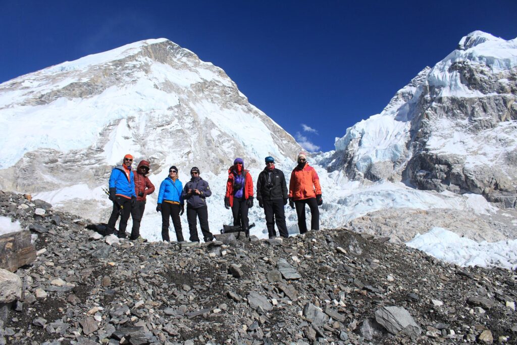
Trekkers on the Khumbu Glacier moraine approaching Everest Base Camp at 5,364 m with the Khumbu Icefall ahead. Photo: Icicles Adventure Treks, CC BY-SA 4.0 via Wikimedia Commons.
Community Trail Updates
Trekked EBC recently? Share your update — Lukla flight status, teahouse prices, trail conditions — in the comments to help the next trekker.
Related Treks
Also see our guides: Transcaucasian Trail, Armenia, Wakhan Corridor, Khinalug to Laza, Azerbaijan.
Last verified: 2026-09-29

Arjun Mehta is the pen name behind Mountains Bliss — practical mountain-travel guides with routes, costs, seasons and safety notes, researched from real trekker discussions and cross-checked before publishing. No sponsored posts, ever.
More about Mountains Bliss →